Data Partners (also referred to as data providers) can allow access to the supplied location information (grid reference, latitude and longitude, coordinate uncertainty, and locality text) for sensitive species data through Access Controls.
Currently supplied location information is only available via the Simple spreadsheet download.
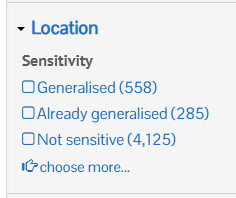
How to identify generalised sensitive species records
You can identify sensitive species records in an occurrence search by enabling the Sensitivity filter To enable this filter click Customise filters, select Sensitivity (located under the Location options), and finally click Update.
Expand the Location filters and view the Sensitivity filter options. If your occurrence search included records for ‘Generalised‘, this indicates that the location information for those records have been generalised, e.g., the grid reference, locality text has been hidden etc.. Therefore, for these records you may wish to contact the Data partner (data provider) to request access to the supplied location information.
Requesting access to sensitive data
For specific guidance on requesting access to Access Controlled records (includes sensitive records), please see here.
Allowing enhanced access to sensitive data
For specific guidance on managing and allowing access to NBN Atlas users for Access Controlled records (includes sensitive records), please see here.
Enhanced access download columns
When a NBN Atlas user completes a download, with records which they have been granted access to the supplied resolution for the records’ location, these additional fields will be included:
| Field name | Description |
| Locality – access controlled | Supplied locality text. |
| Grid reference – access controlled | The supplied or processed grid reference at the supplied resolution. |
| Longitude – access controlled | The supplied or processed longitude at the supplied resolution. |
| Latitude – access controlled | The supplied or processed latitude at the supplied resolution. |
| Coordinate uncertainty (m) – ungeneralised | The supplied or processed Coordinate uncertainty (m) at the supplied resolution. |
For records which the NBN Atlas user has not been granted access to the supplied resolution, these fields will be blank.