All records on the NBN Atlas have a location where they were observed and a measure of precision (or uncertainty) for that location. The location of a records shared with the NBN Atlas must be described either by a:
- latitude-longitude pair of coordinates and a measure of the coordinate uncertainty; or
- National Grid Reference (NGR; OSGB or OSI)
This document details how the NBN Atlas processes grid-based and coordinate-based records.
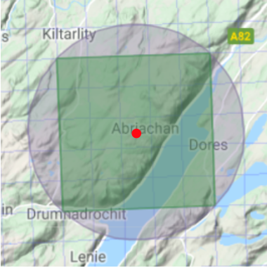
When records are provided with coordinates and an uncertainty, the coordinates pinpoint the centre of the occurrence location (illustrated by the red dot in the image below). The coordinate uncertainty is interpreted as a radius in meters, illustrated by the grey circle in the image below, as per the Darwin Core standard for that term: https://dwc.tdwg.org/terms/#dwc:coordinateUncertaintyInMeters
Conversely, when records are provided with an NGR, the occurrence location is defined by the grid square (as illustrated in green below), and the uncertainty of the record is implied by the size of the grid square. The NBN Atlas will assign latitude and longitude coordinates from the centroid (centre) of the NGR (illustrated by the red dot in the image below) and a coordinate uncertainty as the radius of the circle that goes through all four points of the NGR square, as shown in grey.
Previously, the NBN Atlas used the size of the grid cell as the coordinate uncertainty (e.g. 1,000 m for a record in a 1 km grid cell such as SK5740). This has been adjusted to reflect the radius of the circle touching the corners of the grid cell, i.e. approximately 0.70 m for a record in a 1 km grid cell.
The coordinate uncertainties for the NGR resolutions supported in the NBN Atlas are given in Table 1.
While processing a record, where possible the NBN Atlas infers a NGR for those records supplied with coordinates, and conversely, a pair of coordinates and a coordinate uncertainty for those records supplied with a national grid reference.
1. Coordinates from National Grid References
The NBN Atlas will assign centroid coordinates and a coordinate uncertainty as described above.
To enable consistent comparison between both grid- and coordinate-based records, the NBN Atlas uses the term gridSizeInMeters to store the resolution of the grid square, which is derived from the number of digits of the NGR. gridSizeInMeters is not Darwin Core standard.
We ask that records in Northern Ireland are supplied with an OSI grid reference. NI records supplied with OSGB grid references are correctly processed and given coordinates, but a data quality warning is raised indicating the OSGB NGR.
2. National Grid References from coordinates
Records supplied with coordinates should also have either an accompanying coordinate uncertainty in meters or a grid size in meters (indicating the resolution of the record rather than radius of uncertainty). A coordinate uncertainty is preferred as it is the Darwin Core standard.
The grid reference is inferred from the coordinate location and the grid size is determined from either the coordinate uncertainty in meters or the grid size in meters. Coordinate-based records without a coordinate uncertainty or grid size are not given a grid reference as it is not possible to determine the resolution of the grid.
Records in Northern Ireland are given an OSI grid reference. Records that do not fall within the OSGB or OSI reference systems are not given grid references.
Where both a NGR and coordinates are supplied: if the coordinates are the centroid of the grid square the record is processed as a grid-based record, on the basis that the coordinates are assumed not to be the true location of the record, but rather simply a different representation of the grid cell (i). Where the coordinates are not the centroid (+/- 10%) a data quality warning is raised, to enable the NBN to review these records to ensure that the grid and the coordinates are in agreement with each other. In this case, if a coordinate uncertainty in meters or grid size in meters is supplied, the record is processed as a coordinate-based record (ii), otherwise it is processed as a grid-based record (i).
It is possible to filter and facet search records using either the grid size in meters term or coordinate uncertainty; both searches will retrieve both grid- and coordinate-based records. Note that the actual values that are used to retrieve equivalent records will differ, depending on the term used, see Table 1.
Table 1. The coordinate uncertainties for each national grid reference resolution supported in the NBN Atlas. When determining the national grid reference resolution from a coordinate uncertainty, if the uncertainty is between two thresholds the larger grid size is assigned, e.g. an uncertainty of 6 m is given a 10 m grid reference.
| Grid Size (in meters) | Coordinate uncertainty (in meters) |
|---|---|
| 1 | 0.7 |
| 10 | 7.1 |
| 100 | 70.7 |
| 1,000 | 707.1 |
| 2,000 | 1,414 |
| 10,000 | 7,071.1 |
| 50,000 | 35,355 |
| 100,000 | 70,710.7 |