This page covers the various location search options for occurrence records available on the NBN Atlas, these include:
- Pre-defined areas – e.g., vice counties, local authorities, Local Environmental Record Centres
- Explore your area – searching by an address, postcode, latitude and longitude. You can then specify the distance to include records for from the central point of the searched location (the search radius)
- Polygon – a dedicated page allowing you to draw a polygon, circle, or rectangle to search for records within, or import a WKT.
You can also import shapefiles and KML files, as well as searching from a larger selection of pre-defined areas (referred to as Layers) using the NBN Atlas Spatial Portal, a dedicated tool for exploring and analysing occurrence records. Please see guidance here.
Please be aware that records may be subject to licence conditions and you MUST adhere to these conditions, see Guidance on using data page for further information. These conditions still apply when using summaries/record counts shown on the location search pages.
Searching pre-defined areas
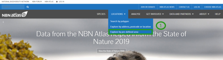
To select an area from selection of pre-defined areas, click Locations from the NBN Atlas homepage (also present on all other NBN Atlas pages) and select Explore by pre-defined area (1).
Select a region from the list. The regions fall into six different categories: Local Authorities GB, Counties Northern Ireland, Local Environmental Centre boundaries, Watsonian Vice Counties, Vice Counties Ireland and National Parks (2).
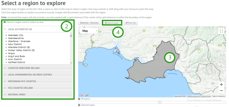
Selecting an area from the drop-down lists will cause it to be highlighted in grey on the map (3). Click Zoom to region to focus on the selected area (4). Click on the highlighted region.
Records for every species are automatically displayed (5) and are detailed on the left (6). From here, you can view and download complete list of records. Use the drop-down boxes to select a species. Now, only records for that species will be displayed on the map.
Please note that counts are based on occurrence records identified to species level. To explore occurrence records for all classification levels (e.g., genus records), you will need to view the records via the View records/View selected records button (7).
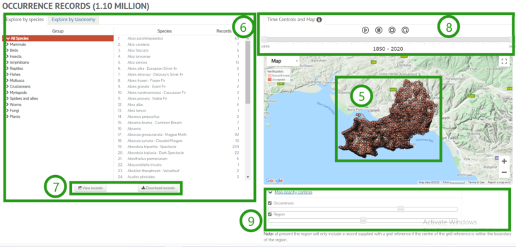
You can use the time controls above the map to display how species have been recorded over time. Click the play button and the records will be displayed by decade, in sequence (8).
Use the Map Opacity Controls and tick boxes to select which records are displayed and alter their appearance (9).
Explore your area
Click Locations from the NBN Atlas home page (see 1, above). Select Explore by address, postcode or location.
On this map, records are displayed within the radius of the specified point (10).
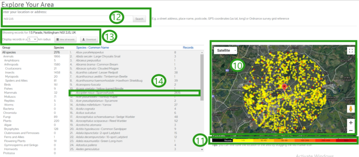
To display records around an address or location, enter it in the search bar (12). You can click and drag the red pin to change the location on the map.
To change the size of the search radius, select 0.1, 0.5, 1, 2, 5 or 10 from the dropdown list (13). The species with records in that search area are listed on the left, next to the number of records for that species (14).
Please note that counts are based on occurrence records identified to species level. To explore occurrence records for all classification levels (e.g., genus records), you will need to view the records via the View records/View selected records button (13).
If searching by a grid reference, we advise using the Advanced search as this provides more accurate results (i.e., only includes records supplied with or within the searched grid reference).
Select a species or species group to display only those records. When you select a species, options will appear below its name for viewing the species’ information profile or a list of all the displayed records.
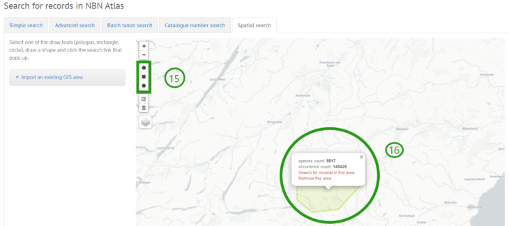
Searching by polygon
Click Locations from the NBN Atlas home page (see 1, above). Select Search by polygon. You will be presented with the spatial search map. Use the drawing tools on the left of the map to draw an area in which to search for records (15). Once you have drawn an area, a dialogue box will tell you the number of species and the total number of records represented in that area.
To import an existing WKT, click Import an existing GIS area and paste the WKT into the displayed text box.
You will be given the option to search for records in the area (16). If you select to search for records in the area, you will be directed Interactive map. See Using the Interactive map guide for further information.
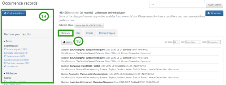
All species records for the area will be displayed, to view a list of all records, click the Records tab (18). The list of records can be filtered if necessary using the Narrow your results panel (19).