This page will provide an overview of Access Controls, covering the following topics:
For specific guidance on requesting access to Access Controlled data, please see here. For specific guidance on managing and allowing access to NBN Atlas users for Access Controlled data, please see here. |
Glossary of Access Control related terms
| Resolution – The spatial uncertainty of a record based on the grid reference or coordinate uncertainty in meters, see Grid and coordinate based records on the NBN Atlas for further guidance.
Public resolution – The coordinate uncertainty or grid square size that the record is viewable at on the NBN Atlas. For set public resolution datasets this will be 1, 2, 5 or 10km grids. Sensitive species – When a record is for a species deemed sensitive in a specified country according to the sensitive species lists. The record is then subject to the generalisation specified in the relevant list. Supplied resolution – The coordinate uncertainty or grid square size as supplied by the data partner in the original datafile. Location – Refers to the grid reference, latitude and longitude coordinates, coordinate-uncertainty and the locality text for a record. Generalised – When the supplied resolution is higher than the resolution displayed on the NBN Atlas (either according to a set public resolution or the sensitive species lists). |
What are Access Controls?
Access Controls are the functionality which allow data partners to specify access to supplied resolution location information for records which have been generalised.
Location information for records may be generalised because the species is deemed sensitive (read more about sensitive species here) or because the records are in a dataset for which the data partner has requested to be displayed at a set public resolution.
How is a public resolution applied to a dataset?
Data partners can request a set public resolution to be applied to new and existing datasets (also referred to as ‘data resource’ on the NBN Atlas).
For new datasets data partners will need to specify the public resolution they want applied in the metadata form, which must be supplied with the data (see Share species occurrence records).
For existing datasets please email data@nbnatlas.org with the name of the dataset and the public resolution (1, 2, 5, or 10km) you would like to be applied. The public resolution will then be applied to your dataset after the next data processing (see the Data processing schedule).
What record information is affected?
The table below lists the fields affected by Access Controls.
| Field name/s | How the field is affected |
| Grid reference |
The grid reference is generalised to the set public resolution or sensitive generalisation. E.g., For a record supplied with a 1m grid reference in a dataset with a 1km set public resolution, the grid reference will be generalised to 1km. If the supplied grid reference resolution is lower than the set public resolution or sensitive generalisation, the supplied grid reference will be used. |
| Coordinate uncertainty in meters |
The coordinate uncertainty in meters is generalised to the set public resolution or sensitive generalisation. E.g., For a record supplied with a coordinate uncertainty (m) of 50 in a dataset with the set public resolution 1km, the coordinate uncertainty will be generalised to 707.1 (1km). If the supplied coordinate uncertainty resolution is lower than the set public resolution or sensitive generalisation, the supplied coordinate uncertainty will be used. |
| Latitude and longitude |
If values are supplied for the Latitude and Longitude fields, the values will be processed and generalised according to the processed coordinate uncertainty in meters. If no values are supplied for the Latitude and Longitude fields, the NBN Atlas will calculate and display the generalised values according to the processed grid reference. |
| Locality | This field is cleared for all records. |
For records which are both sensitive and have a set public resolution, if the sensitive generalisation is higher than the set public resolution, the sensitive generalisation is applied and vice versa.
How sensitive records are displayed on the NBN Atlas
This section covers how sensitive records are displayed on the NBN Atlas.
In the occurrence search
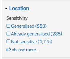
You can identify sensitive species records in an occurrence search by enabling the Sensitivity filter. To enable this filter click Customise filters, select Sensitivity (located under the Location options), and finally click Update.
Expand the Location filters and view the Sensitivity filter options. If your occurrence search included records for ‘Generalised‘, this indicates that the location information for those records have been generalised, e.g., the grid reference, locality text has been hidden etc..
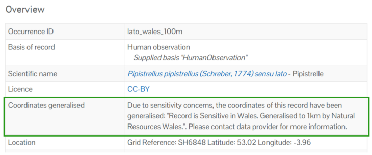
On the record page
The Coordinates generalised field is included in the Overview section, indicating the record is sensitive and subject to generalisation and to access the supplied resolution, the data partner will need to be contacted:
How public resolution records are displayed on the NBN Atlas
This sections covers how records with a set public resolution are displayed on the NBN Atlas or in downloads from the NBN Atlas.
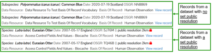
In the occurrence search
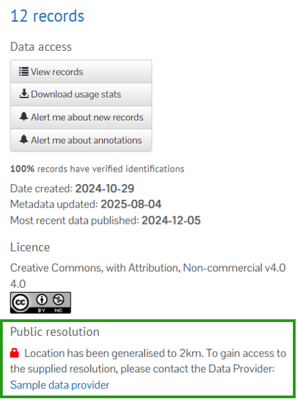
For records in a dataset where a public resolution is set, the set public resolution is displayed (e.g. 2km), along with a padlock icon:
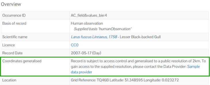
On the record page
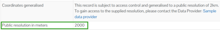
The Coordinates generalised field is included in the Overview section, indicating the record is subject to a set public resolution and to access the supplied resolution, the data partner will need to be contacted:
The Coordinates generalised field is also included in the Geospatial section (towards the bottom of the page), along with the Public resolution in meters field:
In the occurrence download
The public_resolution_in_meters field is included in the Simple Spreadsheet download, and indicates the set public resolution for a record:
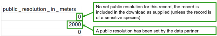
The value in this field is corresponds to the grid size in meters, i.e., in the example above, 2000 represents a 2km grid square uncertainty.
Please note that currently this will not indicate if a record has been generalised according a sensitive species list. For now you will need to refer to the sensitive species lists.
On the dataset (data resource) page
Text is displayed on the dataset page, specifying the records in the dataset are subject to a set public resolution.
Requesting and managing access
Currently NBN Atlas users will need to request access to the supplied resolution externally from the NBN Atlas (i.e., via email). The data partner can then allow access to the supplied resolution for a specified NBN Atlas user. Data partners can specify which records a user can have access to, e.g., all records in a dataset, for a specified species etc.
The data partner will need to know the following to set up appropriate access for a NBN Atlas user [the requester]:
|
If you are a requester or a data partner setting up access for a NBN Atlas user, please use/share the Request access to supplied resolution form to help collect the information above.
How supplied location information is made available
When a data partner allows access for a NBN Atlas user to the supplied location information, they will not be able to see the supplied resolution for a record’s location on the NBN Atlas, currently. The NBN Atlas user will need to navigate to a search with the records and download the records, using the Simple Spreadsheet format to access the supplied location information.
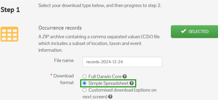
Other download formats are not yet supported.
When a NBN Atlas user completes a download containing records they have been specified access to these additional fields will be included:
| Field name | Description |
| Locality – access controlled | Supplied locality text. |
| Grid reference – access controlled | The supplied or processed grid reference at the supplied resolution. |
| Longitude – access controlled | The supplied or processed longitude at the supplied resolution. |
| Latitude – access controlled | The supplied or processed latitude at the supplied resolution. |
| Coordinate uncertainty (m) – ungeneralised | The supplied or processed Coordinate uncertainty (m) at the supplied resolution. |
For records which are not affected by Access Controls or the NBN Atlas user has not been granted access to the supplied resolution, these fields will be blank.